
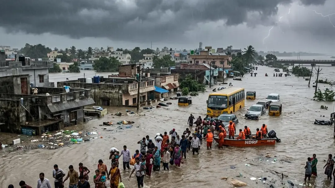
Heavy rain forecast for Andhra Pradesh; flood warnings on rivers
The weather department said the deep depression has weakened and will become a low-pressure area within 24 hours, but heavy rain will continue in Andhra Pradesh for three more days. IMD forecast thunderstorms and winds of 40-60 kmph from September 26 to 29. APSDMA reported over 100 mm of rain at nearly 80 locations on September 23-24, with 236 mm at Thulasinagar. Narayanapuram dam issued a second warning at 76,000 cusecs; Polavaram released 5,36,938 cusecs through 48 gates.
Source
Rajanna Sircilla — weather · read the original report ↗
Desk check · compared with the source
What the desk checked (5)
- The deep depression has weakened into a depression and will become a low-pressure area within 24 hours. — Attributed to the weather department in the source; consistent across the text.
- APSDMA reported over 100 mm rainfall at nearly 80 locations on September 23-24, with Thulasinagar in Visakhapatnam recording 236 mm. — Figures attributed to APSDMA and appear in the source; not independently verified.
- Narayanapuram dam inflow and outflow reached 76,000 cusecs, prompting a second warning. — Attributed to officials in the source; figure appears as given.
- Polavaram project opened 48 gates releasing 5,36,938 cusecs, with spillway level at 30.720 metres. — Specific figures appear in the source without a named official; internally consistent.
- South Telangana may get isolated thunderstorms between October 3 and 10. — Attributed to a private forecaster, 'Telangana Weatherman', and stated as conditional on easterly winds.
Analysts’ view opinion
On the surface this is a weather bulletin, but in Andhra Pradesh floods are never only about weather — they are a public audit of administrative capacity. Rain above 100 mm in nearly 80 locations, readings above 200 mm around Visakhapatnam, a second danger warning at Narayanapuram dam and Polavaram releasing 5,36,938 cusecs through 48 gates are the numbers that will frame the political conversation of the coming days. If warnings, evacuations and relief land on time, the government banks the credit; wherever there is visible delay, the opposition will plant its flag.
- Disaster management is a double-edged sword for any ruling party: a fast, visible response builds goodwill, while even a localised failure becomes a ready-made political charge.
- The worst-hit belts — Visakhapatnam, Vizianagaram and Srikakulam — are politically significant in North Andhra, so compensation and restoration there will draw outsized scrutiny.
- The very large release from Polavaram can revive the long-running political argument around the project, including questions of management and submergence-area concerns.
- With Vamsadhara, Nagavali, Godavari and Krishna flows depending on rainfall in Odisha and Chhattisgarh catchments, inter-state coordination could itself become a political talking point.
- Once crop and infrastructure losses are assessed, demands for central assistance or a special package are likely to dominate the state-centre conversation.
What to watch — Watch how quickly damage assessments, ministerial field visits and compensation announcements follow once the rain eases — that sequencing usually decides who gains politically.
The story is limited to weather and flood data; it establishes nothing about the government's response, any political leader's statements, or the scale of loss to life and property.
Deep dive
Research brief · 8 facts · 8 dates · exam-readyThe brief
Context
A deep depression that brought torrential rain to Andhra Pradesh and Telangana has begun weakening, with the weather department saying it has turned into a depression and will become a low-pressure area within 24 hours. Even so, heavy rain is expected to continue over Andhra Pradesh for two to three more days, with thunderstorms and strong surface winds forecast from September 26 to 29. North Andhra districts, especially Visakhapatnam, recorded extreme rainfall on September 23 and 24, flooding streams and rivers, while the Godavari and Krishna are also in spate due to rains in Odisha and Chhattisgarh.
Key facts
- The deep depression has weakened into a depression and will become a low-pressure area in the next 24 hours, per the weather department.
- IMD forecast thunderstorms and strong surface winds in Andhra Pradesh from September 26 to 29, with winds of 40-60 kmph in some areas; impact drops after September 30.
- APSDMA reported over 100 mm of rainfall at nearly 80 locations in North Andhra on September 23 and 24.
- Visakha Rural Thulasinagar recorded the highest rainfall at 236 mm, followed by Madhurawada 218 mm, Endada 210 mm and Seethammadhara 205 mm.
- Kothavalasa (Vizianagaram) recorded 188 mm and Lakshminarsupeta (Srikakulam) 158 mm.
- Narayanapuram dam issued a second warning as inflow and outflow reached 76,000 cusecs, with a third warning level expected soon.
- Thotapalli on the Nagavali recorded inflow of 24,639 cusecs and outflow of 23,250 cusecs; Dowleswaram barrage on the Godavari recorded inflow and outflow of 4.11 lakh cusecs.
- Polavaram project opened 48 gates to release 5,36,938 cusecs; spillway water level reached 30.720 metres.
Timeline
- September 23-24Heavy rains batter North Andhra; over 100 mm recorded at nearly 80 locations, with 236 mm at Thulasinagar in Visakhapatnam.
- September 26Hyderabad Meteorological Centre predicts more rain in several Telangana districts with winds of 30-40 kmph.
- September 26 to 29IMD forecasts thunderstorms and surface winds of 40-60 kmph in Andhra Pradesh.
- After September 27Weather bulletin shows no major warnings for Telangana.
- Sunday night (as reported)Godavari water levels at Dowleswaram expected to start dropping.
- End of SeptemberSouthwest monsoon expected to withdraw from North Telangana; Telangana to see more heat and humidity.
- After September 30Weather impact in Andhra Pradesh expected to reduce.
- October 3 to 10Telangana Weatherman predicts isolated thunderstorms in South Telangana if easterly winds strengthen.
Who has a stake
- Residents of Coastal and North Andhra — Warned to stay alert for isolated heavy showers, flooded streams and dam releases; advised never to cross overflowing streams.
- APSDMA (Andhra Pradesh State Disaster Management Authority) — Records rainfall data and issues alerts; coordinating response to the North Andhra deluge.
- IMD / Hyderabad Meteorological Centre — Issuing forecasts and warnings on thunderstorms, winds and the weakening system for both states.
- Irrigation and dam officials (Narayanapuram, Thotapalli, Dowleswaram, Polavaram, Prakasam Barrage) — Managing inflows and outflows, issuing graded flood warnings and releasing water safely.
- People in river catchment and low-lying areas of Vamsadhara, Nagavali, Godavari and Krishna — Face flooding risk; advised to stay alert as flood flows may rise further.
- Fishermen — Must strictly follow official warnings before venturing into the sea during strong winds.
- Telangana districts such as Komaram Bheem Asifabad, Adilabad, Mancherial, Bhadradri Kothagudem, Khammam — Likely to receive heavy rain with thunderstorms and 30-40 kmph winds on September 26.
Why it matters
Extreme short-duration rainfall of over 200 mm in urban Visakhapatnam localities and simultaneous flooding of the Vamsadhara, Nagavali, Godavari and Krishna show how a single weather system can stress dams, drainage and livelihoods across two states. With soils already saturated, further rain raises the risk of flash floods even as the system weakens. Graded dam warnings and timely IMD alerts are the main tools available to limit loss of life.
UPSC angle
Prelims pointers
- A deep depression weakens in stages: deep depression to depression to low-pressure area.
- APSDMA is the Andhra Pradesh State Disaster Management Authority, which reported rainfall data for September 23-24.
- Polavaram project is on the Godavari; Dowleswaram barrage is also on the Godavari, while Prakasam Barrage is on the Krishna.
- Vamsadhara and Nagavali are North Andhra rivers; Thotapalli is a project on the Nagavali and Narayanapuram on the Vamsadhara system.
- Cusec is a unit of water flow; Polavaram released 5,36,938 cusecs through 48 gates.
- Godavari and Krishna floods were fed by rains in Odisha and Chhattisgarh, showing upper-catchment dependence.
Mains framing
The Andhra Pradesh rain event illustrates the compounding nature of monsoon hazards: a deep depression delivering over 100 mm in nearly 80 locations within 48 hours, with 236 mm at Thulasinagar, saturated soils in North Andhra and turned streams into torrents, while simultaneous rainfall in the Odisha-Chhattisgarh upper catchments pushed the Godavari and Krishna into flood, forcing Polavaram to release 5,36,938 cusecs through 48 gates and Narayanapuram to issue a second warning at 76,000 cusecs. The implications are twofold: urban localities in Visakhapatnam face drainage failure from cloudburst-like intensity, and downstream low-lying and catchment populations face reservoir-release flooding that is governed by upstream rainfall outside the state. The way forward, as indicated in the source, lies in graded dam warning systems, IMD and Hyderabad Meteorological Centre bulletins for thunderstorm and wind alerts from September 26 to 29, APSDMA rainfall monitoring, advisories against crossing overflowing streams or standing under trees and electric poles, and strict compliance by fishermen with sea warnings until the system's impact fades after September 30.
Key terms
- Deep depression
- An intensified low-pressure system over land or sea that brings widespread heavy rain; it weakens into a depression and then a low-pressure area.
- APSDMA
- Andhra Pradesh State Disaster Management Authority, which reported rainfall figures and issued alerts during the event.
- Cusec
- A measure of water flow rate used for river inflows and dam releases, as in Polavaram's 5,36,938 cusecs.
- Second/third warning at a dam
- Graded flood alert levels based on inflow-outflow; Narayanapuram was at second warning with 76,000 cusecs and nearing the third.
- Telangana Weatherman
- A weather forecaster cited as predicting isolated thunderstorms in South Telangana between October 3 and 10.
- Southwest monsoon withdrawal
- The seasonal retreat of monsoon winds, expected from North Telangana by the end of September, leaving the region mostly dry.
Practice questions
- Discuss how the weakening of a deep depression can still produce sustained heavy rainfall and flooding, using the recent Andhra Pradesh event as an illustration.
- Reservoir operations during floods depend on upper-catchment rainfall in other states. Examine the coordination challenges this creates for flood management on the Godavari and Krishna.
- What role do state disaster management authorities and meteorological centres play in reducing loss of life during extreme rainfall events? Illustrate with the September 23-24 North Andhra rains.
Grounded only in the source report — figures and dates are the source's, not inferred.