
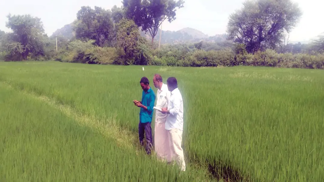
Crop registration 75% complete in Devarakadra constituency
The agriculture department's crop registration drive is about 75% complete across the Devarakadra constituency, officials said. Surveyors are photographing fields and recording details on the Digital Crop Survey Telangana portal using Google Map-based geo-tagging, with AEOs verifying the entries. Cultivated area covered includes Devarakadra 25,370 acres, Bhoothpur 24,366, Musapet 8,136, Addakula 17,729, Chinnachintakunta 24,670 and Koukuntla 16,146 acres. AO Rajendra Agarwal said farmers with objections must contact their cluster AEO within 72 hours of receiving the SMS.
Source
Mahbubnagar — స్థానికం · read the original report ↗
Desk check · compared with the source
What the desk checked (4)
- Crop registration is about 75% complete across the Devarakadra constituency. — Figure appears in source, attributed to the agriculture department's ongoing survey; no document cited.
- Mandal-wise cultivated area: Devarakadra 25,370 acres, Bhoothpur 24,366, Musapet 8,136, Addakula 17,729, Chinnachintakunta 24,670, Koukuntla 16,146 acres. — Figures appear in source as official survey data; internally consistent, no supporting record provided.
- Crop details are recorded digitally on the Digital Crop Survey Telangana portal using Google Map-based geo-tagging and field photographs. — Described in source as departmental procedure; no separate documentation cited.
- Farmers receive an SMS once the survey is done and must contact their cluster AEO within 72 hours if there are errors or objections. — Directly attributed to AO Rajendra Agarwal.
Analysts’ view opinion
Digital crop registration is not merely an administrative exercise — it is the gateway through which a farmer accesses government benefits, credit and procurement. With roughly 1.16 lakh acres across six mandals in Devarakadra now being logged with geo-tagged photographs, entitlements are more likely to be settled on "verified area" rather than "declared area". The economic upside is lower leakage and better planning estimates; the main risk is that a farmer with a data error temporarily falls outside the system.
- The six mandals together account for about 1,16,417 acres of sown area — data that helps the state forecast output, procurement needs and storage capacity in advance.
- Photo-based geo-tagging narrows the scope for duplicate or inflated claims, a gain that accrues first to the exchequer and then to genuine cultivators.
- On the cost side, surveyor deployment and AEO verification carry a real administrative expense, though the story provides no figures on what the exercise costs.
- The 72-hour objection window is the pivotal design choice: it speeds up the process but can disadvantage smallholders and tenant farmers with limited phone or message access.
- Who makes up the remaining 25 per cent matters most, since boundary disputes, joint holdings and leased plots typically settle last and carry the highest risk of benefit exclusion.
What to watch — Watch whether the remaining 25 per cent is completed before the kharif procurement window opens, and how many objections raised within the 72-hour period are actually resolved.
The story establishes only the share of registration completed — it does not tell us the crop-wise breakdown, the cost of the exercise, or whether tenant cultivators benefit from this registration.
Deep dive
Research brief · 8 facts · 2 dates · exam-readyThe brief
Context
Telangana's agriculture department is running a digital crop registration (crop booking) drive for the vanakalam (kharif) season, recording every farmer's cultivated crop on the Digital Crop Survey Telangana portal. Unlike earlier manual methods, surveyors now visit fields, photograph the crop against Google Map-indicated survey numbers and geo-tag the entry, after which Agriculture Extension Officers (AEOs) verify and upload it. In Devarakadra constituency of Mahabubnagar district, officials say the exercise is about 75 per cent complete. The registration is the basis on which farmers access government scheme benefits and sell their produce without hurdles.
Key facts
- Crop registration across Devarakadra constituency is about 75 per cent complete, as reported on September 27, 2026.
- Cultivated area being registered: Devarakadra mandal 25,370 acres; Bhoothpur 24,366 acres; Musapet 8,136 acres.
- Addakula mandal 17,729 acres; Chinnachintakunta 24,670 acres; Koukuntla 16,146 acres of crops under cultivation.
- Crop details are entered on the Digital Crop Survey Telangana portal using Google Map-based geo-tagging, a change from past practice.
- Surveyors photograph fields so the crop is clearly visible, mapped survey number wise, and AEOs then verify and record entries online.
- Farmers receive an SMS on their phones from the agriculture department immediately after the geo-tagged survey of their field is completed.
- AO Rajendra Agarwal said farmers with objections or errors in the entry must approach their cluster AEO within 72 hours of the SMS.
- The drive covers crops grown in the vanakalam (monsoon/kharif) season.
Timeline
- Vanakalam (monsoon) season 2026Agriculture department begins digital crop registration of crops sown by farmers in Devarakadra constituency mandals.
- September 27, 2026Officials report that crop registration is about 75 per cent complete constituency-wide; AO Rajendra Agarwal sets out the 72-hour grievance window.
Who has a stake
- Farmers of Devarakadra constituency — Registration decides access to government scheme benefits and hassle-free sale of produce; they must flag errors within 72 hours of the SMS.
- Telangana Agriculture Department — Owns the drive; must complete accurate, geo-tagged registration across all mandals of the constituency.
- Agriculture Extension Officers (AEOs) — Verify surveyor data, upload it online and handle farmer objections at the cluster level.
- Surveyors — Carry out field-level photography and digital capture of crop details against Google Map survey numbers.
- Agriculture Officer (AO) Rajendra Agarwal — Supervises the process and has said crop registration is mandatory for every farmer.
- Six mandals (Devarakadra, Bhoothpur, Musapet, Addakula, Chinnachintakunta, Koukuntla) — Their cultivated acreage is being digitally recorded, forming the base data for scheme delivery.
Why it matters
Digital, geo-tagged crop registration converts crop data into verifiable field-level evidence, which is what links a farmer to scheme benefits and smooth procurement of produce. The SMS alert plus a 72-hour objection window builds a transparency and grievance-redress layer into the data, reducing the risk of wrong entries denying a farmer his entitlement. For a constituency with over 1.16 lakh acres being recorded across six mandals, the accuracy of this exercise directly shapes who gets support.
UPSC angle
Prelims pointers
- Digital Crop Survey Telangana portal is the platform used for online crop registration in the state.
- Crop registration in Devarakadra constituency was about 75 per cent complete as of September 27, 2026.
- Geo-tagging is done on a Google Map basis, survey number wise, with photographs of the standing crop.
- AEO stands for Agriculture Extension Officer; AEOs verify surveyors' data and record it online.
- Grievance window: 72 hours from the SMS to approach the cluster AEO about errors in crop registration.
- Mandal-wise acreage: Devarakadra 25,370; Bhoothpur 24,366; Chinnachintakunta 24,670; Addakula 17,729; Koukuntla 16,146; Musapet 8,136 acres.
Mains framing
The Devarakadra crop registration drive illustrates the shift from declaration-based to evidence-based agricultural data collection: instead of recording what a farmer states, surveyors visit the field, photograph the crop against the Google Map-indicated survey number, geo-tag it and let AEOs verify before upload on the Digital Crop Survey Telangana portal. The rationale, as officials state, is twofold — ensuring farmers actually receive government scheme benefits and enabling them to sell produce without difficulty, since procurement and support increasingly hinge on authenticated crop and acreage data. The design also embeds accountability: an automatic SMS to the farmer after geo-tagging and a 72-hour window to approach the cluster AEO with objections, making the farmer a checker of his own record rather than a passive subject of the survey. Implementation challenges are visible in the source only indirectly — the drive is 75 per cent complete and covers six mandals with widely varying acreage, from 8,136 acres in Musapet to 25,370 in Devarakadra — implying that coverage, surveyor capacity and timely completion within the season are the operational tests. The way forward lies in closing the remaining survey gap, ensuring every farmer actually receives and understands the SMS, and making the cluster AEO grievance route accessible enough that correction is real rather than notional.
Key terms
- Digital Crop Survey Telangana portal
- The state's online platform on which surveyors and AEOs record field-level crop details for the season.
- Geo-tagging
- Attaching location coordinates (here via Google Map survey numbers) to a crop photograph so the entry is tied to a specific plot.
- AEO (Agriculture Extension Officer)
- Cluster-level agriculture department official who verifies surveyors' crop data, uploads it online and receives farmer objections.
- AO (Agriculture Officer)
- Supervisory agriculture department officer; here Rajendra Agarwal, who explained the mandatory nature of crop registration.
- Vanakalam season
- The monsoon/kharif cropping season, the crops of which are being registered in this drive.
- Crop registration (crop booking)
- Official recording of which crop is grown on which plot, used as the basis for scheme benefits and sale of produce.
Practice questions
- How does geo-tagged digital crop registration improve the targeting of agricultural scheme benefits compared with earlier manual survey methods? Discuss with reference to the Telangana experience.
- Examine the role of field-level functionaries such as Agriculture Extension Officers in making digital agriculture databases reliable, and the safeguards needed for farmer grievance redressal.
- Accurate crop and acreage data is a precondition for both procurement and farm support policy. Critically analyse the challenges in building such databases at the mandal level.
Grounded only in the source report — figures and dates are the source's, not inferred.