
Nirmal's seven streets named after days of the week
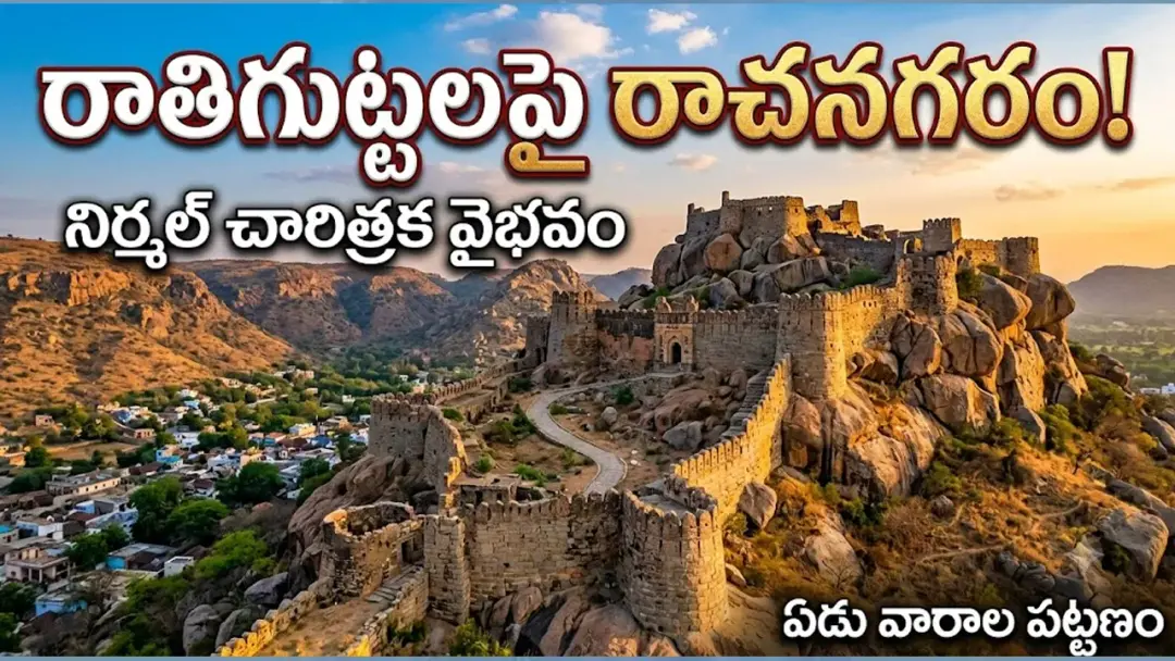
Local history records that Telangana's Nirmal town took shape about 400 years ago with seven streets named after the seven days of the week — Somavarpet, Bangalpet, Budhavarpet, Bestavarpet, Jummeratpet, Balajiwada and Ravi Nagar. The town is named after 17th-century ruler Nimma Naidu. At its centre, the 20-acre Khillagutta hill holds an assembly hall, a dance hall and secret passages. The Godavari flows 16 km away.
Source
Nirmal — స్థానికం · read the original report ↗
Desk check · some claims need care
What the desk checked (6)
- Nirmal town was formed about 400 years ago with seven streets named after the seven days of the week (Somavarpet, Mangalpet/now Bangalpet, Budhavarpet, Bestavarpet, Jummeratpet, Balajiwada, Ravi Nagar). — Figure and street names appear in the source; attributed only to local history, no document cited.
- The town is named after 17th-century ruler Nimma Naidu, under whom fort building and patronage of arts expanded. — Stated in source as historical background; no specific source or record named.
- Khillagutta in the town centre spans about 20 acres and holds queen's chambers, an assembly hall, a dance hall, wells, a temple, stone water trough, armouries and secret passages. — Details and acreage appear in the source; not attributed to a survey or department.
- Nirmal's rocky hills stand about 350 metres above sea level and the Godavari flows 16 km from the town centre. — Figures appear in the source; no measuring authority cited.
- Lord Rama stayed for some time at Gandi Ramanna kshetram during his Godavari circuit. — Presented in the source as puranic narrative and local belief, not as fact.
- Nirmal's light 'poniki' wood toys, made by 'Naksha' artisans since the 14th century, have geographical recognition. — Claim appears in source; GI status mentioned without issuing authority.
Analysts’ view opinion
On the surface this is a heritage feature, but its political subtext is clear. Nirmal — which the story notes grew into a district headquarters after Telangana's formation as a separate state — is sitting on assets that translate easily into political demand: a 400-year-old town plan of seven weekday-named streets, the 20-acre Khillagutta fort complex, and a craft tradition with geographical recognition. The line in the story about heritage being "neglected" is itself the political hook: it frames preservation as an unmet obligation, and that is a question any actor can pick up.
- In newly elevated district headquarters, "recognition for our history" is usually the lowest-cost, least divisive platform available to local leadership.
- If conservation of the fort, hillock and temples ever converts into budget lines or a tourism circuit, expect competition over who claims credit for it.
- The seven street names mix Hindu and Islamicate naming traditions and the story notes idols of several faiths in the town centre — material that can be used both to argue a shared, composite heritage and, conversely, to feed renaming politics.
- The story says the Nirmal wooden-toy craft has geographical recognition, making artisan livelihoods and market support a natural local election promise.
- Crucially, no party, leader or government decision appears anywhere in this account — the political implications are potential, not demonstrated.
What to watch — Watch whether any formal proposal or funding allocation emerges for conserving Nirmal's fort and heritage sites, and which level of leadership steps forward to claim it.
The story establishes no government announcement, funding, party position or political demand, and its historical claims rest largely on local history and researchers' accounts.
Deep dive
Research brief · 8 facts · 7 dates · exam-readyThe brief
Context
Nirmal, now a district headquarters in Telangana, is a town on the Deccan plateau whose layout carries its history: local accounts say it was formed about 400 years ago with seven streets named after the seven days of the week. The town's name is traced to Nimma Naidu, a 17th-century ruler under whom fort-building and patronage of arts grew. The area passed through the Satavahanas, Rashtrakutas, Kalyani Chalukyas, Kakatiyas, Padmanayakas (Rechella Velamas), Qutb Shahis, Nizams and local Khilladars, leaving temples, rock hills, forts and tanks across the town.
Key facts
- Nirmal took shape as a town of seven streets named after the seven weekdays about 400 years ago, per local history.
- The seven streets: Somavarpet (Monday), Mangalpet — now Bangalpet (Tuesday), Budhavarpet (Wednesday), Bestavarpet (Thursday), Jummeratpet (Friday), Balajiwada (Saturday) and Ravi Nagar (Sunday).
- The town is named after Nimma Naidu, a ruler of the region in the 17th century; fort construction and arts patronage grew in his time.
- Khillagutta hill at the centre of Nirmal spreads over about 20 acres, with queen's chambers, an assembly hall (sabhamandapam), a dance hall, sister wells, a temple, a stone water trough for soldiers, armouries and secret passages.
- Seven main gateways of strong stone were built for entry into the town; Golusula Darwaza was the largest, on the north-south route, and Palapitta Darwaza in the centre served internal movement.
- The royal town was laid out over roughly 10 km; Nirmal's rocky hills stand about 350 metres above sea level on the Deccan plateau.
- The Godavari river flows just 16 km from Nirmal's town centre.
- Light toys and art forms made from local 'poniki' wood have been famous since the 14th century, made by 'Naksha' artisans, and the craft has received geographical recognition.
Timeline
- Satavahana eraNirmal, part of the Assaka (Asmaka) janapada among the sixteen mahajanapadas, was under Satavahana rule — evidenced by pottery, potsherds, mud forts, bricks and Buddhist stupas.
- Kalyani Chalukya periodA trade centre called 'nakaramulu' existed at Nirmal; Nakareshwarawada later became Nagareshwarawada, where a Chalukya-era Shiva temple still stands.
- Kakatiya periodOmkareshwara temple built near Khajana Cheruvu.
- 14th century onwardsPoniki-wood toys and paintings by Naksha artisans gain fame.
- 17th centuryNimma Naidu rules the region; town gets the name Nirmal; forts built and arts patronised.
- About 400 years agoNirmal formed as a town of seven weekday-named streets; the 'kasuba' settlement of Nimma Naidu's time expanded into a royal town.
- After Telangana statehoodNirmal grew into a district headquarters.
Who has a stake
- Residents of Nirmal town — Live in streets whose weekday names carry the town's 400-year identity, even as names change (Mangalpet to Bangalpet).
- Naksha artisans — Makers of Nirmal's poniki-wood toys and paintings, a craft with geographical recognition, dependent on continued demand and support.
- Dr. Tummala Devarao, history researcher, and Rasam Sridhar, senior journalist — Argue Nirmal's hills, forts and tanks lack upkeep and that this generation must pass on its 'golden history'.
- Heritage and tourism authorities (state/district) — Responsible for conserving Khillagutta, the stone gateways, temples and inscriptions cited as neglected.
- Devotees and local faith communities — Temples such as Nagareshwara Shiva temple, Omkareshwara, Venkateswara and Padmakshi, Gandi Ramanna kshetram, and idols of many religions in the town centre.
Why it matters
Street names are among the cheapest and most durable records a town keeps of how it grew; Nirmal's weekday streets preserve the sequence in which rulers expanded a 'kasuba' settlement into a royal town. The same town holds Chalukya and Kakatiya temples, seven stone gateways, a 20-acre hill fort and a 14th-century wood-craft tradition with geographical recognition — assets that local historians say are decaying for want of attention.
UPSC angle
Prelims pointers
- Nirmal's seven weekday streets: Somavarpet, Bangalpet (earlier Mangalpet), Budhavarpet, Bestavarpet, Jummeratpet, Balajiwada, Ravi Nagar.
- Nirmal is named after Nimma Naidu, a 17th-century ruler of the region.
- Khillagutta hill in central Nirmal covers about 20 acres and has an assembly hall, dance hall and secret passages.
- Nirmal lies about 350 m above sea level on the Deccan plateau; the Godavari is 16 km from the town centre.
- Nirmal is identified with the Assaka (Asmaka) janapada of the sixteen janapadas; Satavahana-era pottery and Buddhist stupas have been found.
- Nirmal's poniki-wood toys and paintings, made by Naksha artisans since the 14th century, have geographical recognition.
Mains framing
Nirmal illustrates how urban toponymy functions as historical evidence: its seven streets named for the days of the week record the phased expansion of a small 'kasuba' settlement into a royal town roughly four centuries ago, while layers of rule — Satavahanas, Rashtrakutas, Kalyani Chalukyas, Kakatiyas, Padmanayakas, Qutb Shahis, Nizams and local Khilladars — survive in the Nagareshwara and Omkareshwara temples, hero-stones and Umamaheshwara images, the seven stone gateways including Golusula and Palapitta Darwazas, and the 20-acre Khillagutta with its assembly hall, dance hall, armouries and secret passages. Geography reinforced this continuity: the Godavari only 16 km away supported settlement and civilisation, and local poniki wood sustained a 14th-century craft of light toys and paintings that today carries geographical recognition. Yet, as the history researcher and senior journalist quoted in the report note, the hills, forts and tanks are heavy with history but starved of care. The way forward suggested by the account itself is documentation and transmission — recording this heritage, protecting the built remains and craft livelihoods, and making the present generation the custodian that hands the record to the next.
Key terms
- Kasuba
- The term used for Nirmal as a settlement unit in Nimma Naidu's time, before it expanded into a royal town.
- Khillagutta
- The roughly 20-acre fortified rock hill at Nirmal's centre with royal chambers, assembly and dance halls and secret passages.
- Nakaramulu / Nakareshwarawada
- A trade centre at Nirmal in the Kalyani Chalukya period; its memory survives in the locality name, later Nagareshwarawada.
- Naksha artisans
- The craftspeople who make Nirmal's light poniki-wood toys and paintings depicting Ramayana, Mahabharata and Kakatiya styles.
- Assaka (Asmaka) janapada
- One of the sixteen janapadas, to which Nirmal is said to have belonged before Satavahana rule.
- Golusula and Palapitta Darwazas
- Two of Nirmal's stone gateways — the largest on the north-south route, and the central one used for internal movement.
Practice questions
- How do place names and street names serve as sources for reconstructing urban history? Illustrate with the case of Nirmal in Telangana.
- Discuss the archaeological and architectural evidence of successive dynastic rule in Nirmal, from the Satavahanas to the Nizams, and the challenges in conserving such dispersed heritage.
- Traditional crafts with geographical recognition, such as Nirmal's poniki-wood toys, link livelihoods to local ecology and history. Examine the measures needed to sustain them.
Grounded only in the source report — figures and dates are the source's, not inferred.