
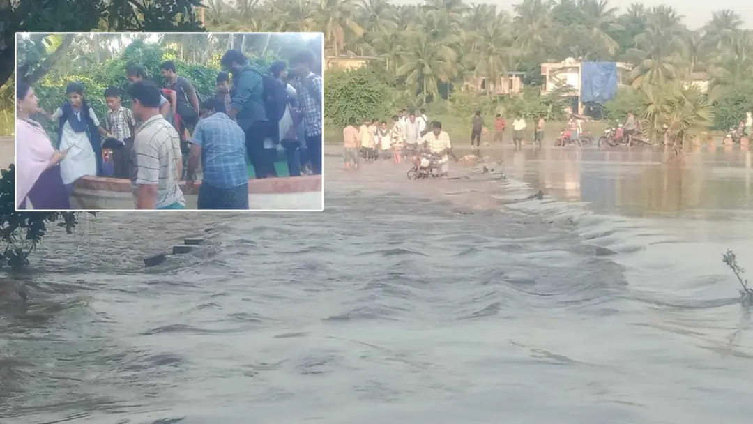
Godavari flood submerges Kanakayalanka causeway, cuts off Lanka villages
Rising Godavari floodwaters submerged the Kanakayalanka causeway in P. Gannavaram mandal of Dr. B.R. Ambedkar Konaseema district, halting traffic between Konaseema and West Godavari districts and leaving Lanka village residents affected. District Collector Mahesh Kumar is reviewing the situation. At the Dowleswaram Sir Arthur Cotton Barrage the level reached 11.60 feet; the first warning will be issued at 11.75 feet. Officials lifted 175 gates, releasing 9,62,000 cusecs into the sea.
Source
Konaseema — వార్తలు · read the original report ↗
Desk check · compared with the source
What the desk checked (5)
- Floodwater submerged the Kanakayalanka causeway in P. Gannavaram mandal, halting traffic between Konaseema and West Godavari districts. — Stated in source without named official attribution; figure-free situational claim.
- Water level at Dowleswaram Sir Arthur Cotton Barrage reached 11.60 feet, near the first warning level of 11.75 feet. — Figures appear in source; attributed to the situation at the barrage, irrigation officials cited for the outlook.
- 175 gates of the Dowleswaram barrage were lifted and 9,62,000 cusecs of surplus water is being released into the sea. — Specific figures appear in source; no named official attributed to them.
- District Collector Mahesh Kumar is reviewing flood conditions and issuing instructions to officials. — Attributed to the district administration in the source; name appears as given.
- Floodwater may also reach the Ainavilli-Edurubidiyam causeway if the flow rises further. — Presented as an estimate attributed to officials.
Analysts’ view opinion
A submerged causeway in the Konaseema lanka belt is a routine monsoon event on paper, but politically it is a recurring test of whether the state has fixed the connectivity gap it promises to fix every flood season. With the district collector personally reviewing and 175 gates open at Dhavaleswaram, the administration is signalling pre-emptive control rather than crisis — which is exactly the frame a ruling establishment wants before any danger warning is issued. The bigger political risk here is not the water level but the isolation of lanka villages, an issue opposition leaders traditionally raise as evidence of neglected bridge and causeway infrastructure.
- Flood management in the Godavari delta is judged less on rainfall than on response optics, and an officer-led, warning-focused posture is designed to pre-empt accusations of unpreparedness.
- The cut-off between Konaseema and West Godavari districts revives the long-standing demand for permanent high-level bridges over causeway crossings — a classic local electoral issue in lanka constituencies.
- No political leader is quoted in the story, so credit or blame has not yet been assigned; that vacuum usually gets filled quickly by visits and photo-ops from both ruling and opposition camps.
- Irrigation officials' assessment that the first danger warning may not be breached gives the government breathing room, but also sets a benchmark it will be held to if levels rise.
- Konaseema's wider grievance stack — including aqua farmers' agitation over input costs flagged in the same news cycle — means flood disruption lands on already restive rural ground.
What to watch — Watch whether the water level crosses the 11.75-feet first warning mark at Dhavaleswaram and whether ministers or opposition leaders begin touring the lanka villages — the point at which a relief exercise turns into a political contest.
The story establishes only the flood and administrative response; it does not report any political statement, criticism, relief package, evacuation or casualty, and offers no evidence on whether infrastructure lapses contributed.
Deep dive
Research brief · 8 facts · 3 dates · exam-readyThe brief
Context
Heavy inflows from upstream catchments have pushed the Godavari into spate in coastal Andhra Pradesh, with the flood's effects concentrated in Dr. B.R. Ambedkar Konaseema district. Floodwater has completely submerged the Kanakayalanka causeway in P. Gannavaram mandal, cutting the road link between Konaseema and West Godavari districts and isolating the low-lying "Lanka" (river island) villages. Downstream at Dowleswaram, the Sir Arthur Cotton Barrage — the structure that regulates Godavari water into the delta canals and the sea — is running close to its first warning level, with 175 gates lifted to pass surplus water to the sea.
Key facts
- Floodwater fully submerged the Kanakayalanka causeway in P. Gannavaram mandal of Dr. B.R. Ambedkar Konaseema district, halting traffic from Konaseema to West Godavari district.
- Water level at the Sir Arthur Cotton Barrage, Dowleswaram, reached 11.60 feet — close to the first danger warning level.
- The first danger warning is likely to be issued if the level reaches 11.75 feet.
- Officials lifted 175 gates of the Dowleswaram barrage to pass the heavy inflow.
- Surplus water of 9,62,000 cusecs is being released from the barrage into the sea.
- Flow has increased in all the Godavari distributaries in Konaseema — Godavari, Vainateya, Vasishta, Gautami and Vruddha Gautami.
- District Collector Mahesh Kumar is reviewing flood conditions continuously and issuing instructions to officials.
- Officials estimate that if the flood intensifies further, water may also reach the Ainavilli–Eduru Bidiyam causeway.
Timeline
- Recent hours before the reportGodavari flood flow remained steady, leading irrigation officials to assess that chances of crossing the first warning level are low.
- At the time of the reportKanakayalanka causeway submerged; barrage level at 11.60 feet; 175 gates lifted and 9,62,000 cusecs released to the sea.
- If flood rises furtherWater may reach the Ainavilli–Eduru Bidiyam causeway; first warning to be issued at 11.75 feet.
Who has a stake
- Residents of Lanka (river island) villages — Facing severe hardship as the submerged causeway cuts their only road access.
- Dr. B.R. Ambedkar Konaseema district administration — On alert, monitoring the flood and taking precautionary measures.
- District Collector Mahesh Kumar — Reviewing flood conditions round the clock and directing officials; warning people in affected areas.
- Irrigation Department officials — Operating the Dowleswaram barrage gates, monitoring levels and judging whether the first warning is needed.
- Travellers between Konaseema and West Godavari districts — Movement halted due to causeway submergence; advised not to travel over causeways.
- People in low-lying areas — Advised not to enter floodwater unnecessarily and to stay alert.
Why it matters
Causeways are the lifeline of Konaseema's Lanka villages, and a single submergence severs health, market and school access for entire island settlements. The barrage level and the volume of water being pushed to the sea are the operational signals that decide whether warnings, evacuations and traffic bans follow, making real-time monitoring central to delta flood safety.
UPSC angle
Prelims pointers
- Sir Arthur Cotton Barrage is located at Dowleswaram on the Godavari; it regulates flood water and delta supplies.
- Godavari distributaries in Konaseema named in the source: Godavari, Vainateya, Vasishta, Gautami and Vruddha Gautami.
- Kanakayalanka causeway lies in P. Gannavaram mandal, Dr. B.R. Ambedkar Konaseema district.
- First danger warning level cited at Dowleswaram: 11.75 feet; observed level 11.60 feet.
- 175 gates of the Dowleswaram barrage were lifted to release 9,62,000 cusecs into the sea.
- Cusec = cubic foot per second, the unit used for river discharge and barrage releases.
Mains framing
The Konaseema flood episode illustrates how deltaic geography converts moderate upstream inflows into acute local isolation: as water from upper catchments enters the Godavari, it spreads across the Gautami, Vasishta, Vainateya and Vruddha Gautami distributaries, and low-level causeways such as Kanakayalanka become the first infrastructure to fail, severing inter-district connectivity and stranding Lanka village populations. The administrative response in the source is largely anticipatory and information-driven — the Collector reviewing conditions, warnings to low-lying residents against entering floodwater or using causeways, and irrigation officials calibrating the first warning threshold of 11.75 feet against an observed 11.60 feet at Dowleswaram while passing 9,62,000 cusecs to the sea through 175 lifted gates. The implication is that flood management in the delta depends as much on barrage gate operations and graded warning levels as on last-mile connectivity assets. A grounded way forward, consistent with the source, is sustained real-time monitoring, early identification of vulnerable causeways such as Ainavilli–Eduru Bidiyam, strict enforcement of travel advisories, and pre-positioned alternative access for island habitations; the source does not state any longer-term infrastructure plan.
Key terms
- Causeway
- A low-level road crossing over a water channel that goes under water when river levels rise, as at Kanakayalanka.
- Lanka villages
- Habitations on river islands and low-lying pockets within the Godavari's channels, first to be cut off during floods.
- Sir Arthur Cotton Barrage, Dowleswaram
- Barrage on the Godavari that regulates flood discharge and delta irrigation supplies; has gates that are lifted during floods.
- First danger warning
- Initial official flood alert level at the barrage; to be issued if the level touches 11.75 feet.
- Cusecs
- Measure of water discharge (cubic feet per second); 9,62,000 cusecs of surplus was being released to the sea.
- Distributaries of the Godavari
- Branches such as Gautami, Vasishta, Vainateya and Vruddha Gautami through which the river reaches the sea in Konaseema.
Practice questions
- How do low-level causeways shape flood vulnerability in India's deltaic districts? Discuss with reference to the Godavari delta in Konaseema.
- Explain the role of barrages such as the Sir Arthur Cotton Barrage at Dowleswaram in flood regulation, and how graded warning levels guide administrative action.
- Examine the preparedness measures a district administration should take to protect river-island (Lanka) habitations during river floods.
Grounded only in the source report — figures and dates are the source's, not inferred.