
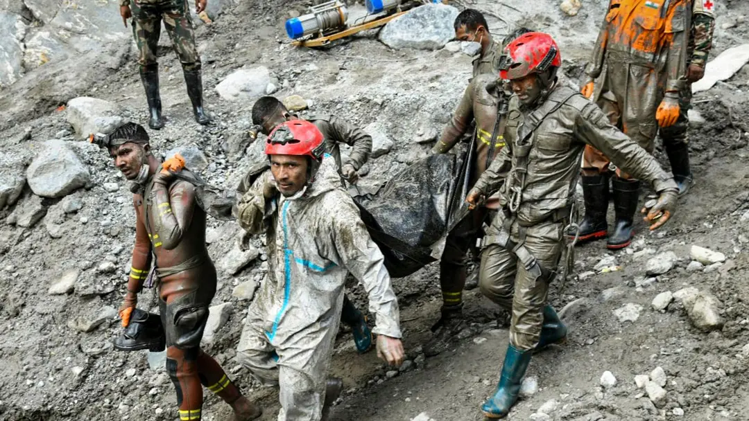
Fresh floods hit Nepal as death toll reaches 1,453
Relentless rainfall across Nepal since September 24 has triggered fresh floods and landslides, swept away houses and disrupted road traffic. The National Disaster Risk Reduction and Management Authority said the toll from the disaster has reached 1,453, with more than 5,000 missing and 13,795 people rescued. In Butwal, Rupandehi district, the Tinau River crossed its danger mark, washing away six houses and forcing about 1,000 evacuations. In Chitwan, the Narayani River reached 9.23 metres.
Source
PTI wire · read the original report ↗
Desk check · compared with the source
What the desk checked (5)
- At least 1,453 people killed and more than 5,000 remain missing in Nepal floods. — Attributed to a media report and NDRRMA data in the source; figures appear consistently, with 1,451 bodies recovered plus two deaths during treatment.
- 13,795 people rescued till Saturday. — Attributed to the NDRRMA in the source.
- Tinau River swept away six houses in Butwal; about 1,000 people evacuated overnight and around 200 houses at risk. — Attributed to the Kathmandu Post and an unnamed police official.
- Narayani River reached 9.23 metres at Devghat, above the 9-metre danger level. — Figure attributed to the Department of Hydrology and Meteorology via the Kathmandu Post.
- Flooding inundated 389 houses in Nawalparasi West and Saptari districts on Saturday. — Figure appears in source; no specific agency named for this count.
Analysts’ view opinion
Nepal's floods and landslides have moved beyond a humanitarian emergency into the territory of a Himalayan security problem. A toll of 1,453 dead with more than 5,000 still missing — from flash flooding that the story says originated near the Nepal-Tibet border — points to sustained strain on state capacity, mountain connectivity and border-area administration. When arteries like the Karnali Highway and the Karnali Corridor are severed by landslides, the exposed weakness is strategic as much as it is administrative.
- A death toll of 1,453 with over 5,000 missing in a month is beyond routine monsoon loss and into national-disaster scale, which ties down army, police and security personnel in prolonged relief duty.
- The NDRRMA figure of 13,795 rescued shows the response machinery is functioning, but the gap against the missing count underlines real capacity limits.
- Blocked routes — the Karnali Highway, the Karnali Corridor, the Nagna-Gamgadhi road — make it harder to push supplies and relief into remote mountain districts, affecting both civil protection and governance reach in border areas.
- The story notes the flash floods originated near the Nepal-Tibet border, which makes upstream flow information-sharing and joint monitoring a plausible regional diplomatic theme.
- The Narayani and Saptakoshi crossing danger levels signals mounting pressure downstream on the plains toward the Indian border, where river-data exchange matters most.
What to watch — Watch river levels in Karnali, Chitwan and Rupandehi if rain persists, how quickly blocked highways are reopened, and whether Nepal seeks external assistance or regional disaster cooperation.
The story establishes casualty, rescue and river-level figures only; it does not establish that any country has offered aid, that any inter-governmental talks have occurred, or what happened upstream across the border.
Deep dive
Research brief · 8 facts · 6 dates · exam-readyThe brief
Context
Nepal has been battered by disaster for about a month, beginning with flash floods that originated near the Nepal-Tibet border and devastated towns and villages in northern and central Nepal. Relentless rainfall since Thursday, September 24 has now triggered a fresh wave of floods, landslides and mudslides across Lumbini, Bagmati and Karnali provinces. The National Disaster Risk Reduction and Management Authority (NDRRMA) is coordinating the toll count and rescue effort, while the Department of Hydrology and Meteorology tracks river gauges against warning and danger levels. Rivers including the Tinau, Narayani, Riu and several Karnali tributaries have crossed or approached danger marks, prompting mass evacuations and road blockages.
Key facts
- NDRRMA says at least 1,453 people have died in the disaster; bodies of 1,451 recovered till Saturday and two others died during treatment.
- More than 5,000 people remain missing; 13,795 people have been rescued till Saturday, per NDRRMA.
- Rainfall has been relentless since Thursday, September 24; the original flash floods struck about a month earlier near the Nepal-Tibet border.
- In Butwal, Rupandehi district (Lumbini province), the Tinau River crossed its danger mark around 8 pm Saturday and swept away six houses.
- About 200 riverbank houses in Butwal were at risk; security personnel evacuated around 1,000 people overnight, including 500 from Majhuwa in Butwal Metropolitan City-13.
- At the Devghat gauge station in Chitwan, the Narayani River reached 9.23 metres at about 5.15 am Sunday, against a 7.3-metre warning level and 9-metre danger level.
- The Riu stream reached 3.92 metres against a 3.4-metre warning and 3.8-metre danger level.
- On Saturday, flooding from the Narayani and Saptakoshi rivers inundated 389 houses in Nawalparasi West and Saptari districts.
Timeline
- About a month before the reportFlash floods originating near the Nepal-Tibet border devastate towns and villages in northern and central Nepal.
- Thursday, September 24 onwardsRelentless rainfall across Nepal triggers fresh floods, landslides and road disruption.
- SaturdayNarayani and Saptakoshi flooding inundates 389 houses in Nawalparasi West and Saptari; NDRRMA tally reaches 1,451 bodies recovered and 13,795 rescued.
- Saturday, around 8 pmTinau River crosses its danger mark at Butwal; rescue and evacuation operations begin.
- Saturday nightSix houses along the Tinau riverbank in Butwal swept away; about 1,000 people evacuated overnight.
- Sunday, around 5.15 amNarayani River hits 9.23 metres at Devghat; Riu stream at 3.92 metres, both above danger levels.
Who has a stake
- National Disaster Risk Reduction and Management Authority (NDRRMA) — Nepal's apex disaster body compiling casualty, missing and rescue figures and coordinating response.
- Department of Hydrology and Meteorology — Monitors gauge stations and issues warning/danger level readings that trigger evacuations.
- Residents of Butwal, Rupandehi — Six houses lost, around 200 riverbank homes at risk, about 1,000 people evacuated to temples and schools.
- Chitwan district communities — Narayani and Riu above danger levels; landslides at Dharapani and Simaldhara blocking roads in both directions.
- Karnali province districts (Dolpa, Humla, Mugu, Kalikot, Jumla) — Rising rivers and mudslides blocking the Karnali Highway, Karnali Corridor and Nagna-Gamgadhi road.
- Security personnel and district administrations — Conducting rescue, evacuation and public alerts for people living near rivers and streams.
- Families of over 5,000 missing persons — Awaiting news amid continuing search operations a month after the flash floods.
Why it matters
A death toll of 1,453 with more than 5,000 still missing makes this one of the gravest recent disasters in the Himalayan region, and fresh rainfall is compounding losses before recovery can begin. The blocking of the Karnali Highway and Karnali Corridor shows how landslides can cut off remote mountain districts from relief. For India, upstream Himalayan floods on shared river systems such as the Karnali, Narayani and Saptakoshi carry direct downstream consequences.
UPSC angle
Prelims pointers
- NDRRMA (National Disaster Risk Reduction and Management Authority) is Nepal's apex disaster management body; it put the toll at 1,453 with 13,795 rescued.
- Tinau River flows through Butwal in Rupandehi district, Lumbini province; it crossed its danger mark on Saturday night.
- Narayani River danger level at Devghat gauge station is 9 metres and warning level 7.3 metres; it reached 9.23 metres.
- The Riu stream flows along the boundary of Madi and Chitwan National Park, joins the Rapti near Meghauli and drains into the Narayani.
- Karnali tributaries in the news: Thuli Bheri (Dolpa), Mugu Karnali (Mugu), Tila Karnali (Kalikot, Jumla), Sija (Jumla).
- The original flash floods originated near the Nepal-Tibet border, hitting northern and central Nepal about a month earlier.
Mains framing
Nepal's compounding flood-landslide emergency illustrates the cascading nature of Himalayan hydro-meteorological hazards: flash floods originating near the Nepal-Tibet border devastated northern and central Nepal, and relentless rain since September 24 has produced a second wave of floods, mudslides and road subsidence before the first crisis was resolved. The scale — 1,453 dead, over 5,000 missing, 13,795 rescued, 389 houses inundated in Nawalparasi West and Saptari alone — reflects dense riverbank settlement (around 200 at-risk houses in Butwal), steep fragile slopes and limited evacuation infrastructure, with displaced people first moved to a temple holding centre and then to schools. Institutional response rests on NDRRMA coordination plus gauge-based thresholds from the Department of Hydrology and Meteorology, where the Narayani at 9.23 metres against a 9-metre danger level and the Riu at 3.92 metres against 3.8 metres show the value of graded warning systems; equally, blocked arteries such as the Karnali Highway, Karnali Corridor and Nagna-Gamgadhi road show that relief logistics are the weak link in mountain districts. The way forward suggested by the source is anticipatory action: district administrations urging riverside residents to stay alert and pre-emptively relocate, sustained real-time river monitoring, and resilient road and shelter arrangements in flood- and landslide-prone areas.
Key terms
- NDRRMA
- Nepal's National Disaster Risk Reduction and Management Authority, which issued the casualty, missing and rescue figures.
- Department of Hydrology and Meteorology
- Nepal's agency that operates river gauge stations and defines warning and danger water levels.
- Warning level vs danger level
- Graded river-height thresholds: warning triggers alerts, danger triggers evacuation, as at Devghat (7.3 m and 9 m).
- Devghat gauge station
- Measuring point on the Narayani River in Chitwan where the river touched 9.23 metres on Sunday morning.
- Karnali Corridor
- Road link in Nepal's Karnali region; traffic was disrupted by landslides at Khaccha, Gopchegauda and Yalwang in Humla.
- Flash flood
- Sudden, rapid-onset flooding; this episode originated near the Nepal-Tibet border and hit northern and central Nepal.
Practice questions
- Discuss why Himalayan river basins are prone to cascading flood and landslide disasters, using Nepal's 2025 floods as an illustration.
- Evaluate the role of gauge-based warning and danger level systems in disaster risk reduction. What are their limitations in mountainous terrain?
- Transboundary Himalayan floods require cooperative early-warning mechanisms. Examine in the context of India-Nepal shared river systems such as the Karnali, Narayani and Saptakoshi.
Grounded only in the source report — figures and dates are the source's, not inferred.