
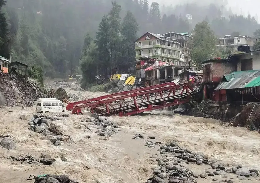
ORF analysis urges climate-resilient planning in Indian Himalayas
Nepal's floods should serve as a warning for India, says an Observer Research Foundation analysis. The Indian Himalayan economy spans nearly 2,500 km across 13 states and Union Territories and houses almost 50 million people. The Hindu Kush Himalayan region lost around 12 percent of its glacier area between 1990 and 2020. The 2021 Chamoli disaster killed more than 200 people, while the 2023 South Lhonak GLOF destroyed 13 bridges and the 1,200-MW Teesta-III project, causing Sikkim an estimated INR 18,555 crore in damage.
Source
Observer Research Foundation (ORF) · read the original report ↗
Desk check · compared with the source
What the desk checked (5)
- The Hindu Kush Himalayan region lost about 12 percent of its glacier area between 1990 and 2020, with ice loss rate doubling since 2000. — Figure appears in source; no originating study named.
- The 2021 Chamoli disaster killed more than 200 people and damaged two hydropower projects totalling over 530 MW. — Stated in source without separate citation; internally consistent.
- The 2023 South Lhonak GLOF destroyed 13 bridges and the 1,200-MW Teesta-III project, with damage estimated at INR 18,555 crore in Sikkim. — Specific figure given in source; no agency attributed for the estimate.
- CWC monitors 902 glacial lakes and water bodies above 10 hectares; of 47 dams identified as GLOF-exposed, studies were done for 31 as of 2024. — Attributed in source to the Central Water Commission.
- CDRI estimates India's annual average disaster-related infrastructure losses at nearly US$32 billion, with 10-15% extra resilience spending returning seven to twelve times. — Attributed to the Coalition for Disaster Resilient Infrastructure.
Analysts’ view opinion
Though framed as climate analysis, the real question here is one of power: who gets to decide where building is allowed in the Himalayas, and where it is not. Making the Central Water Commission's monitoring and the NDMA's existing guidelines legally binding would mean constraining state governments' authority over land use and building permissions — a natural seedbed for Centre–state friction. The detail that Sikkim's estimated INR 18,555 crore in damage exceeded its annual budget sharpens a fiscal-political fight over who bears disaster costs.
- A region spanning 13 states and UTs with nearly 50 million residents makes this a multi-government, multi-party problem rather than a single state's concern.
- Over six crore pilgrims and tourists in Uttarakhand in 2025 and 1.81 crore in Himachal Pradesh in 2024 mean tourism-dependent local constituencies and construction interests are natural sources of resistance to new restrictions.
- Giving hazard zonation legal teeth — deciding where not to build — would curb the discretion of local legislators and municipal bodies, which is precisely why technically sound recommendations are politically hard to implement.
- That the South Lhonak lake was known to be dangerous years earlier yet no operational warning reached downstream communities gives opposition parties a potent accountability line after any future event.
- The gap between 47 dams flagged and only 31 studies completed by 2024 invites Centre-versus-state blame politics over administrative pace.
What to watch — Watch whether any move is made to make hazard zonation legally consequential for Himalayan master plans and project reports, and how state governments, tourism and construction interests respond.
This is an individual ORF author's analysis; the story does not establish that the government has accepted these recommendations, nor does it record any party's position or any policy decision.
Deep dive
Research brief · 8 facts · 7 dates · exam-readyThe brief
Context
An Observer Research Foundation (ORF) analysis by Aparna Roy argues that recent floods in Nepal should be a warning for India's Himalayan development model. The Indian Himalayan economy stretches nearly 2,500 km across 13 states and Union Territories, houses almost 50 million people and supports hydropower, tourism and connectivity infrastructure. Glacier loss, expanding glacial lakes, intense rainfall and unstable slopes are making historical climate and hydrological records unreliable for planning assets meant to last 50-100 years. The analysis proposes three shifts: detecting risk, regulating exposure and pricing resilience upfront.
Key facts
- The Indian Himalayan economy spans nearly 2,500 km across 13 states and Union Territories and houses almost 50 million people.
- The Hindu Kush Himalayan region lost around 12 percent of its glacier area between 1990 and 2020, and the rate of ice loss has doubled since 2000.
- The 2021 Chamoli disaster killed more than 200 people and damaged two hydropower projects with a combined capacity exceeding 530 MW.
- The 2023 South Lhonak GLOF destroyed 13 bridges and the 1,200-MW Teesta-III project, leaving Sikkim with an estimated INR 18,555 crore in damage - more than the state's annual budget.
- The Central Water Commission monitors 902 glacial lakes and water bodies larger than 10 hectares; the INR 150-crore National GLOF Risk Mitigation Programme covers four Himalayan states.
- After the 2023 disaster, CWC identified 47 dams potentially exposed to GLOFs; as of 2024, studies had been completed for only 31.
- CDRI estimates India's annual average infrastructure losses from disasters at nearly US$32 billion; an extra 10-15 percent investment in resilient design can return seven to twelve times through avoided losses.
- Uttarakhand received more than six crore tourists and pilgrims in 2025; Himachal Pradesh received 1.81 crore tourists in 2024.
Timeline
- 1990-2020Hindu Kush Himalayan region loses around 12 percent of its glacier area.
- Since 2000Rate of ice loss in the region doubles.
- 2021Chamoli disaster kills more than 200 people and damages two hydropower projects totalling over 530 MW.
- 2023South Lhonak GLOF destroys 13 bridges and the 1,200-MW Teesta-III project; Sikkim's damage estimated at INR 18,555 crore.
- After 2023 GLOFCWC identifies 47 dams potentially exposed to GLOFs.
- 2024Studies completed for only 31 of the 47 identified dams; Himachal Pradesh records 1.81 crore tourists.
- 2025Uttarakhand receives more than six crore tourists and pilgrims; Nepal floods prompt ORF warning for India.
Who has a stake
- Nearly 50 million residents of the Indian Himalayan Region — Lives, livelihoods and access to connectivity, electricity and essential services during recurring disasters.
- 13 Himalayan states and Union Territories — Fiscal exposure - Sikkim's 2023 losses alone exceeded its annual budget - plus hydropower, tourism and road assets.
- Central Water Commission (CWC) — Monitoring 902 glacial lakes and completing GLOF exposure studies for 47 identified dams.
- National Disaster Management Authority (NDMA) — Its landslide-management guidelines and floodplain zoning must become legally consequential for permissions.
- NITI Aayog — Has argued Himalayan tourism growth must be governed by local carrying capacity.
- CDRI (Coalition for Disaster Resilient Infrastructure) — Its Resilience Cost-Benefit Analysis framework is offered as a ready tool for project appraisal and financing.
- Hydropower developers and infrastructure agencies — Projects designed on past hydrology face reconstruction, downtime and cascading loss risks.
Why it matters
Himalayan infrastructure built for 50-100 years of service is still planned on historical weather and hydrological records that a fast-changing cryosphere has made unreliable, converting single events into state-sized fiscal shocks. The analysis shows India already has hazard detection capacity but lacks the forecast-to-action link and legal force to stop new construction in high-risk zones. Without that, Himalayan disasters risk becoming recurring crises costing lives, livelihoods and growth.
UPSC angle
Prelims pointers
- GLOF = Glacial Lake Outburst Flood; South Lhonak lake GLOF (2023) hit Sikkim's Teesta valley and the 1,200-MW Teesta-III project.
- Indian Himalayan Region: nearly 2,500 km across 13 states and UTs, almost 50 million people.
- CWC monitors 902 glacial lakes/water bodies above 10 hectares; National GLOF Risk Mitigation Programme is worth INR 150 crore and covers four Himalayan states.
- CDRI puts India's annual average disaster-linked infrastructure losses at nearly US$32 billion; 10-15 percent extra resilience spending can yield 7-12 times returns.
- NDMA landslide-management guidelines provide for hazard zonation; floodplain zoning is part of India's disaster-risk framework.
- Hindu Kush Himalaya lost about 12 percent of glacier area, 1990-2020; ice loss rate doubled since 2000.
Mains framing
India's Himalayan infrastructure push - roads, tunnels, bridges, hydropower and pilgrimage facilities - is expanding precisely when the climatic assumptions behind it are weakening: retreating glaciers, expanding glacial lakes, intense rainfall and unstable slopes interact in ways historical records cannot anticipate. The 2021 Chamoli disaster (200+ deaths, 530+ MW damaged) and the 2023 South Lhonak GLOF (13 bridges, Teesta-III, INR 18,555 crore loss to Sikkim) show that hazard identification without operational warning is not risk reduction: South Lhonak was known to be dangerous years earlier, yet no warning reached downstream communities, and only 31 of 47 GLOF-exposed dams had studies done by 2024. The ORF analysis proposes three connected shifts - judging early-warning systems by the lead time they buy through impact-based forecasting, forecast-based action protocols, inundation mapping, pre-defined thresholds and SOPs backed by redundant sensors and power; pricing failure through climate-risk screening, lifecycle costing and resilience cost-benefit analysis in DPRs, stress-tested against 2070-2080 projections rather than past data; and regulating exposure by embedding multi-hazard zonation in statutory land-use planning and Development Control Regulations, with carrying capacity including evacuation capacity. The framing is not development versus conservation, but infrastructure designed for tomorrow's risks rather than yesterday's records.
Key terms
- GLOF (Glacial Lake Outburst Flood)
- Sudden release of water from a glacial lake, as at South Lhonak in 2023, sending destructive floods down valleys.
- Impact-based forecasting / forecast-based action
- Linking a forecast to what it will damage and to pre-agreed actions such as road closures, evacuations and asset protection.
- Resilience Cost-Benefit Analysis (CDRI)
- A CDRI framework to weigh extra resilience spending against avoided future losses in project appraisal, financing and procurement.
- Development Control Regulations (DCRs)
- Statutory rules governing what can be built and at what density; the analysis wants hazard zonation embedded in them.
- Carrying capacity
- The limit of visitors or construction a destination can sustain; NITI Aayog argues Himalayan tourism must respect it, including evacuation capacity.
- Detailed Project Report (DPR)
- Core appraisal document for public projects, where the analysis urges climate-risk screening and lifecycle costing be mandatory.
Practice questions
- Hazard maps that do not change where construction occurs are 'information, not risk reduction.' Examine how India can make multi-hazard zonation legally consequential for Himalayan land-use planning.
- Discuss why early-warning systems in the Himalayas should be judged by the lead time they create rather than the alerts they issue, using the 2023 South Lhonak GLOF as an example.
- 'Resilience must be an upfront investment criterion, not a reconstruction cost.' Critically evaluate this in the context of infrastructure appraisal in the Indian Himalayan Region.
Grounded only in the source report — figures and dates are the source's, not inferred.