
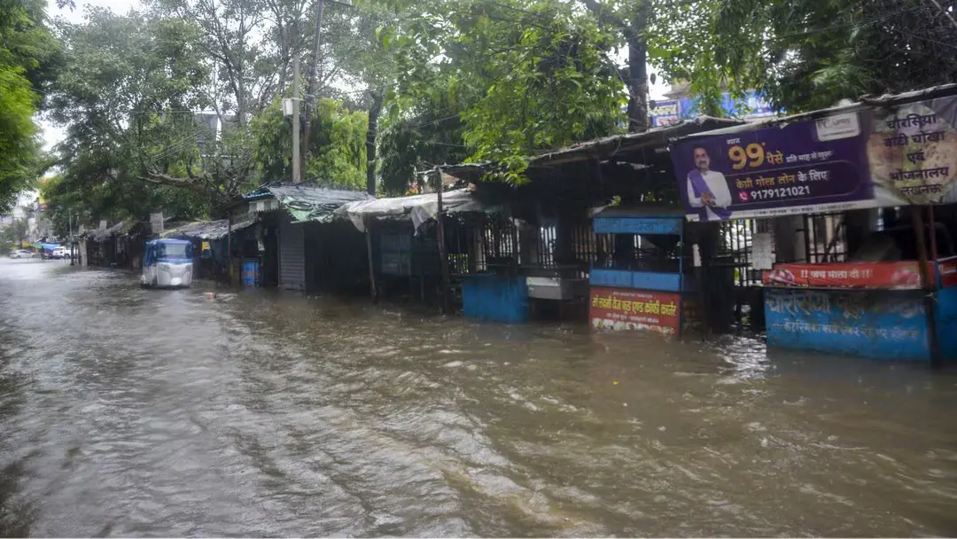
IMD forecasts rain in northern states till September 30
The India Meteorological Department has said rain and drizzle across northern states, from Rajasthan to Bengal, will continue till September 30. It cited a depression over the north Andaman Sea and adjoining Myanmar coast and an active Western Disturbance over Northwest India. Thunderstorms are likely in eastern Rajasthan, Haryana, Chandigarh-Delhi, Punjab and western Uttar Pradesh, and in northeastern states on September 29. Winds of 50-60 kmph and heavy rain are expected over the Andaman Islands. Fishermen were advised against venturing to sea until October 1.
Source
Weather · read the original report ↗
Desk check · compared with the source
What the desk checked (5)
- Rain and thunderstorms will continue from Rajasthan to Bengal till September 30 — Attributed to an IMD bulletin in the source; dates appear consistently in the text.
- A low-pressure area over the north Andaman Sea intensified into a depression on the morning of September 28 and would cross the Myanmar coast between Yangon and Kyaikto by evening — Attributed to IMD; place names and timing stated in source.
- Winds of 50-60 kmph and heavy rain expected over the Andaman Islands on September 28 and 29 — Figure appears in source, attributed to IMD forecast.
- A western disturbance or cyclonic circulation lies over northern Pakistan and adjoining Jammu at 5.8-7.6 km above mean sea level — Technical detail stated in source without named official; consistent with IMD bulletin framing.
- Fishermen advised against venturing into the Andaman Sea, northeastern Bay of Bengal and Myanmar and Bangladesh coasts until October 1 — Advisory stated in source, attributed to the weather department.
Analysts’ view opinion
This reads as a weather bulletin, but politically it is a test of administrative preparedness. The alert stretches from Rajasthan to Bengal and takes in Delhi, Punjab, Haryana, the Northeast and the Andamans — meaning the Centre and states run by different parties must respond at the same time. Late-September rain overlapping with the kharif harvest window, plus urban waterlogging risk, makes compensation and relief politics an almost inevitable next chapter. The story itself reports no political reaction — this is a forecast, not yet a crisis.
- An advance warning is a double-edged sword politically: act well and governments claim credit, fall short and the opposition asks why a flagged risk was not managed.
- Because the affected belt spans states governed by different parties, Centre-state coordination and the speed of fund release could quickly become a talking point.
- Late-September rain touches farm politics directly — crop-loss assessments, insurance payouts and relief demands are the likely follow-on issues.
- In urban centres like Delhi and Chandigarh, waterlogging and traffic disruption tend to trigger blame-shifting over civic agency performance.
- The advisory keeping fishermen off the sea until October 1 raises a livelihood-loss question that coastal fishing constituencies often press politically.
What to watch — Watch how quickly state governments order damage surveys and announce relief after September 30, and whether Centre-state sniping over the response begins.
The story only sets out IMD forecasts; it does not establish that damage has occurred, what any government has done, or that any political reaction has taken place.
Deep dive
Research brief · 8 facts · 7 dates · exam-readyThe brief
Context
The India Meteorological Department (IMD) has forecast continued rain and drizzle across a broad northern belt stretching from Rajasthan to Bengal in the closing days of September. Two systems are driving the weather: a depression that formed over the north Andaman Sea near the Myanmar coast, and an active Western Disturbance over Northwest India. The bulletin also flags thunderstorms, lightning, strong winds and heavy rain at isolated places, with advisories for fishermen in the Andaman Sea and northeastern Bay of Bengal.
Key facts
- IMD says drizzle and rain will continue across northern states from Rajasthan to Bengal till September 30.
- A low-pressure area over the north Andaman Sea off the Myanmar coast intensified into a depression on the morning of September 28.
- The depression was expected to cross the Myanmar coast between Yangon and Kyaikto by the evening of September 28.
- Winds of 50-60 kmph and heavy rainfall were forecast for the Andaman Islands on September 28 and 29.
- Thunderstorms, lightning and light to moderate rain were forecast on September 28 for eastern Rajasthan districts including Alwar, Bharatpur, Dausa, Deeg, Dholpur, Jaipur, Jhunjhunu, Karauli, Khairthal-Tijara, Kotputli-Behror and Sikar.
- Western Rajasthan districts Bikaner, Churu, Didwana-Kuchaman, Hanumangarh, Nagaur and Sriganganagar may see rain with thunder, lightning and strong winds.
- Thunderstorms were forecast for Assam, Meghalaya, Nagaland, Manipur, Mizoram and Tripura on September 29.
- A western disturbance/cyclonic circulation lies over northern Pakistan and adjoining Jammu at 5.8-7.6 km above mean sea level.
Timeline
- Morning of September 28Low-pressure area over north Andaman Sea off the Myanmar coast intensified into a depression.
- September 28Thunderstorms, lightning and light to moderate rain forecast in listed districts of eastern and western Rajasthan.
- September 28 and 29Heavy rainfall and winds of 50-60 kmph expected over the Andaman Islands.
- Evening of September 28Depression expected to cross the Myanmar coast between Yangon and Kyaikto.
- September 29Thunderstorms forecast over Assam, Meghalaya, Nagaland, Manipur, Mizoram and Tripura.
- Till September 30Rainy conditions expected to persist across the northern states.
- Until October 1Fishermen advised against venturing into the Andaman Sea, northeastern Bay of Bengal and Myanmar and Bangladesh coasts.
Who has a stake
- India Meteorological Department (IMD) — Issues the bulletins, warnings and advisories on which state agencies and the public act.
- Fishermen in the Andaman Sea and northeastern Bay of Bengal — Advised not to venture to sea until October 1 due to the depression and strong winds; loss of fishing days.
- Residents of Rajasthan, Haryana, Chandigarh-Delhi, Punjab and western Uttar Pradesh — Exposed to thunderstorms, lightning and strong winds over the next few days.
- Andaman and Nicobar Islands — Facing heavy rainfall and winds of 50-60 kmph on September 28 and 29.
- Northeastern states (Assam, Meghalaya, Nagaland, Manipur, Mizoram, Tripura) — Thunderstorms forecast on September 29.
- Uttarakhand — Heavy rainfall very likely at isolated places, a risk in hilly terrain.
Why it matters
Late-September rain over the northern plains coincides with the withdrawal phase of the southwest monsoon and the kharif harvest, when unseasonal thunderstorms and strong winds can damage standing crops and disrupt transport. Timely IMD warnings on lightning, 50-60 kmph winds and sea conditions allow districts to prepare and keep fishermen ashore, reducing loss of life and livelihood.
UPSC angle
Prelims pointers
- A depression is a low-pressure system stronger than a low; the Andaman Sea system intensified into a depression on September 28.
- Western Disturbance: extratropical system moving eastwards that brings rain to Northwest India; the current one lies over northern Pakistan and adjoining Jammu at 5.8-7.6 km above mean sea level.
- IMD forecast winds of 50-60 kmph over the Andaman Islands on September 28-29.
- Fishermen advisory covered the Andaman Sea, northeastern Bay of Bengal and Myanmar and Bangladesh coasts until October 1.
- Yangon and Kyaikto (Myanmar) marked the stretch of coast the depression was to cross.
- Heavy rainfall very likely at isolated places over Uttarakhand and Andaman and Nicobar.
Mains framing
The late-September spell described in the IMD bulletin illustrates how India's weather in the monsoon-withdrawal period is shaped by the interaction of two distinct systems: a tropical depression that formed over the north Andaman Sea near the Myanmar coast, and a mid-latitude Western Disturbance embedded over Northwest India at 5.8-7.6 km above mean sea level, reinforced by a cyclonic circulation over northwest Uttar Pradesh in the lower troposphere. The result is a wide footprint of impacts - thunderstorms and lightning over eastern and western Rajasthan, Haryana, Chandigarh-Delhi, Punjab and western Uttar Pradesh; heavy rain and 50-60 kmph winds over the Andaman Islands; heavy rain at isolated places over Uttarakhand; and thunderstorms over six northeastern states on September 29. Such compound events test the granularity of forecasting and the last-mile reach of warnings, since the hazards differ by region: lightning and crop damage in the plains, landslide and flash-flood risk in the hills, and sea-state danger for fishermen, who were told to stay ashore until October 1. The way forward, as the bulletin itself suggests, lies in district-level nowcasts, prompt dissemination of maritime advisories, and preparedness by local administrations for short-duration but high-impact weather.
Key terms
- India Meteorological Department (IMD)
- The national weather agency that issues forecasts, bulletins and warnings, including the advisory in this story.
- Depression
- An intensified low-pressure system over the sea; the north Andaman Sea low became one on the morning of September 28.
- Western Disturbance
- A cyclonic circulation moving in from the west that brings rain, thunderstorms and strong winds to Northwest India.
- Low-pressure area
- A weaker cyclonic system; one over northern parts of central Uttar Pradesh brought rains but has since dissipated.
- Cyclonic circulation
- A rotating wind pattern at a given height; one is active over northwest Uttar Pradesh in the lower troposphere.
- Fishermen advisory
- A warning against venturing to sea; issued here for the Andaman Sea, northeastern Bay of Bengal and Myanmar-Bangladesh coasts till October 1.
Practice questions
- Explain how the interaction of a tropical depression and a Western Disturbance can produce widespread rain and thunderstorm activity over northern India during the monsoon withdrawal phase.
- Discuss the role of the India Meteorological Department's warning and advisory system in reducing loss of life and livelihood among coastal fishing communities.
- What are Western Disturbances, and why are they significant for the weather and agriculture of Northwest India?
Grounded only in the source report — figures and dates are the source's, not inferred.